8 Most Beautiful Regions in Indonesia
Long influenced by foreign powers interested in its natural resources, Indonesia today is a Muslim-majority nation with a lot to offer the world. From Javanese coffee to Balinese art and architecture, the fame of Indonesia is global.
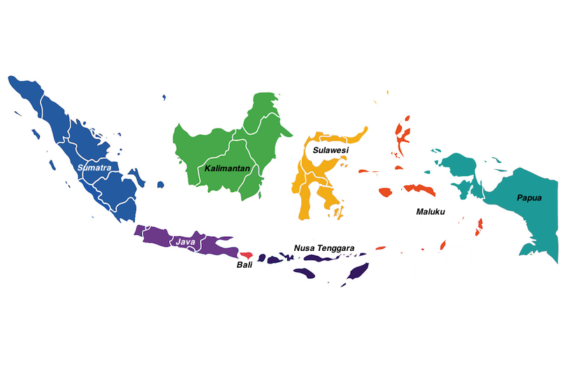
It’s also the world’s largest island country, with over 17,000 islands making up its scattered landmass. Jakarta, its capital, is a world city boasting the second-most populous urban area on Earth: over 30 million people live in this megalopolis.
With all those islands comes beaches and reefs, and with its location on the Ring of Fire comes volcanoes and jagged landscapes. The natural scenery and wildlife of Indonesia is diverse, and made all the more exciting from being strewn across its myriad islands.
Sumatra
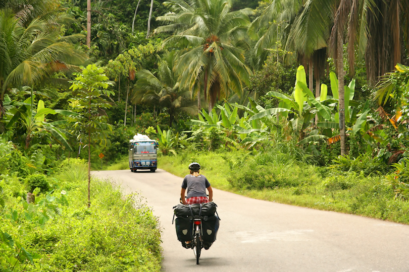
The sixth-largest island in the world – and the largest island that’s located completely in Indonesia – Sumatra sprawls both northwest and southeast of the equator in the west of the archipelago. Naturally, it’s hot and humid.
Once upon a time, almost the entire island was dominated by rainforest, but in the past 35 years, around half the jungles have been lost to deforestation. There are many critically endangered endemic species here – from the Sumatran orangutan and the Sumatran tiger to the Sumatran elephant and the Sumatran rhino.
The west features the almost 1,000-mile-long Barisan Mountains, while the east is characterized by swampy plains. In the north, the largest city is Medan, forming the largest metropolitan area outside of Java. Batam is another large city located in the Riau Islands, just south of Singapore.
Back on the mainland, Lake Toba is an incredibly breathtaking volcanic lake – the result of the largest (known) explosive eruption to have occurred in the last 25 million years.
Kalimantan
While the Malaysian states of Sarawak and Sabah – as well as tiny Brunei – make up northern Borneo, the larger, southern portion is referred to in Indonesia as Kalimantan. The name is derived from the Sanskrit word Kalamanthana – meaning “island with hot weather,” it aptly describes the climate here.
The provinces are Central, North, South, East, and West Kalimantan, with two of the region’s largest cities – Balikpapan and Pontianak (located on the equator) – situated in East and West respectively.
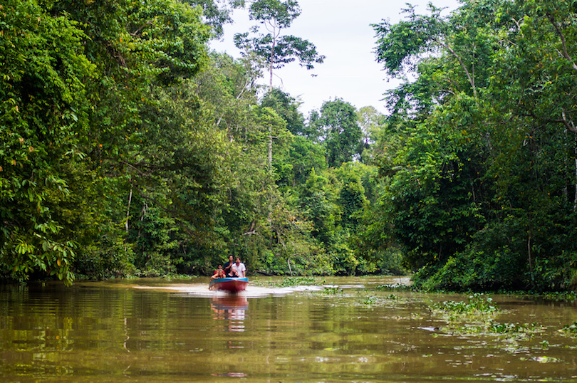
The island can be further subdivided into seven ecosystems – mangroves and montane rainforest in the central highlands, heath forests and freshwater swamp forests in Southwest Borneo, peat swamp forests and tropical grasslands in South Kalimantan, and of course, rainforests. At over 140 million years old, the Borneo Rainforest is one of the oldest in the world.
It’s here where you can get a chance to spot the critically endangered Bornean orangutan; try Tanjung Puting National Park on the south coast of Central Kalimantan.
Between Sumatra in the west and Bali in the east, with Kalimantan to the north and remote Christmas Island to the south, Java is the 13th largest island in the world – and the world’s most populous. This Indonesian landmass is home to sprawling Jakarta and many other big cities, like Bandung, Semarang, and Yogyakarta.
Java
Between Sumatra in the west and Bali in the east, with Kalimantan to the north and remote Christmas Island to the south, Java is the 13th largest island in the world – and the world’s most populous. This Indonesian landmass is home to sprawling Jakarta and many other big cities, like Bandung, Semarang, and Yogyakarta.
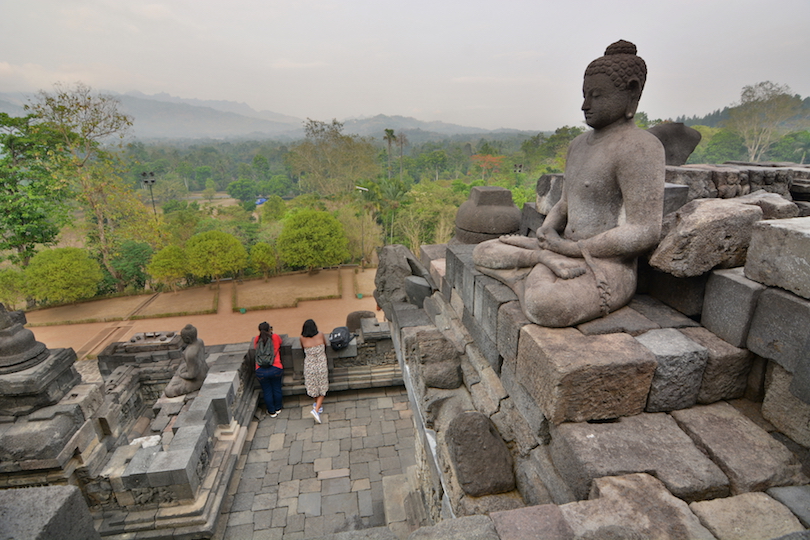
Near Yogyakarta is the enigmatic Borobudur. This is a Buddhist temple that dates back all the way to the 9th century AD; in fact, it’s the largest Buddhist temple in the world. Another historic gem is the 9th-century Hindu temple of Prambanan and is
Java is almost entirely volcanic, with more thanIndonesia’s biggest temple site. 150 mountains, making it the perfect site for coffee growing; plateaus and highlands play host to coffee Arabica, notably on the Ijen Plateau.
The natural environment of the island comprises rainforests, mangrove forests, and volcanic interiors. Mount Bromo is arguably Java’s most famous peak. An active volcano and only 2,329-metres-tall, it’s popular with hikers who go there for sunrise and to peek inside its crater. Mount Semeru – whose name means “Abode of the Gods” – is the highest at 3,376m.
From the mountains to the east coast, Pandangaran Beach Nature Reserve is a special example of Java’s white-sand beaches.
Bali
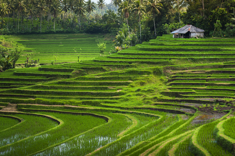
Almost touching eastern Java, the region of Bali consists of the main island itself as well as the paradise islands of Nusa Penida, Nusa Ceningang, and Nusa Lembongan.
With a built-up south and a relatively rural, mountainous north, Bali attracts visitors with its stunning Hindu temples – like the stunning cliff temple at Uluwatu – famous rice terraces at Ubud, and sunset beaches. In fact, it’s Indonesia’s prime tourist destination, with everyone from surfers to those looking for luxury pampering well catered for.
The beautiful beaches of Bali range from jam-packed Seminyak Beach to more secluded options like Thomas Beach, as well as black-sand Amed Beach on the northeastern coast with its offshore coral reef.
Inland, active volcano Mount Batur can be hiked for great views from its summit of the surrounding hills, including the old Mount Batur, whose crater is now occupied by a large lake.
Nusa Tenggara
Perfectly exemplifying Indonesia’s island-filled geography, Nusa Tenggara is a southeastern archipelago made up of some of the countries laser visited Island
Meaning “southeast Islands,” this region stretches from Lombok just east of Bali, through remote Sumbawa and Flores, all the way to West Timor. It’s all about white sands, fantastic diving opportunities, discovering waterfalls, and hidden cultures. From humid jungle in the north to dry savannah in the east, it’s this chain of islands that separates Asia from Australia to the south.
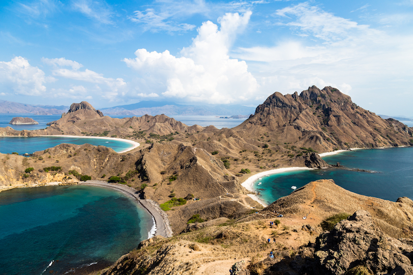
Comprising Komodo, Rinca, and Padar Islands, Komodo National Park is famous for the giant Komodo Dragons – the world’s largest living lizard. There’s more than just reptiles to see though, with a rich marine environment, too.
On Lombok, the island’s cities, beaches, and waterfalls are loomed over by massive Mount Rinjani (3,726m). Flores, to the east of Komodo Island, is famous for its three, jewel-colored crater lakes, located inside the Kelimutu National Park.
Sulawesi
Just east across the Makassar Strait from Kalimantan is Sulawesi. The 11th largest island in the world, this oddly shaped landmass is made up of four peninsulas, with gulfs separating each one; this makes for an interesting place to explore.
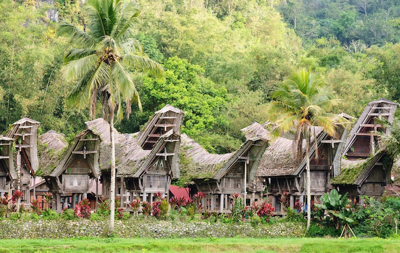
The center of Sulawesi comprises rugged mountains. This terrain is where you’ll find Tana Toraja, home of the Toraja people, known for their bloody funeral rites and distinctive building style, tongkonan, characterised by buildings with huge, dramatically sweeping roofs. and there are also some active volcanoes on the northern peninsula in the provinces of Gorontalo and North Sulawesi.
This region is also known for its incredible dive spots, several of which can be found within the boundaries of Bunaken National Marine Park – a collection of islands off the northernmost town. Here, you’ll discover almost 400 species of coral and an abundance of marine life. The Togian Islands in the Tomini Gulf also boast some stunning underwater scenery.
Bantimurung Bulusaraung is an area of karst caves and waterfalls where you can spot a plethora of butterflies; the Rammang Rammang Karst Area here is the second-largest in the world
Maluku
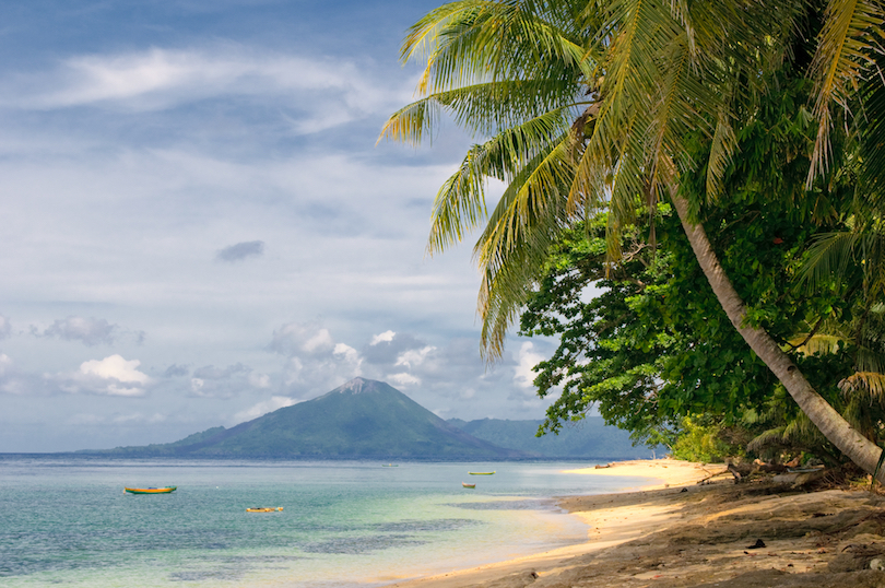
Maluku is a collection of over a thousand islands between Sulawesi and the province of West Papua. For centuries, this province of Indonesia was known as the Spice Islands. Since as early as the 9th century, traders from the west (first Arab, and later Dutch) brought home the spoils of the islands’ native cloves, as well as nutmeg and mace from its nutmeg trees.
Today, this archipelago is a little-visited gem. There’s Manusela National Park on Seram Island, made up of coastal forests, turquoise sea, swamps, rainforests and six mountains – the highest of which is Mount Binaiya (3,027m). There are over 200 bird species calling this park home.
In the Banda Islands, you can marvel at the rainbow corals just off the coast and spot sharks and other marine life in the ancient, underwater lava flows. Top scuba diving sites can be found in Pulau Banda, where long stretches of sandy beach give way to crystal clear waters.
Papua (Western New Guinea)
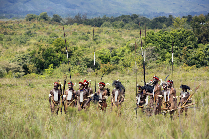
The easternmost province of Indonesia, Papua takes up the western half of the island of New Guinea, bordering the country of Papua New Guinea to the east. This province is practically roadless and its people – ethnically different to other Indonesians – still hunt using traditional methods, making it feel worlds, if not ages, away from the rest of the island country.
Papua’s landscape is dominated by a mountain range, which is where you will find Puncak Jaya. The tallest peak between the Himalayas and the Andes at a whopping 4,884 meters above sea level, it’s the world’s 9th most prominent peak.
The southern and northern lowlands of Papua encompass large tracts of wetlands, rich rainforests, mangrove forests, as well as savannah grasslands for a surprisingly varied landscape.
Lorentz National Park is the largest in Southeast Asia and is one of the most ecologically diverse national parks in the world, containing a plethora of ecosystems. Between the province of Papua and West Papua is Cenderawasih Bay National Park, known for its whale shark population.


No comments:
Post a Comment